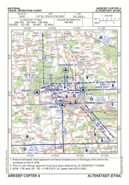
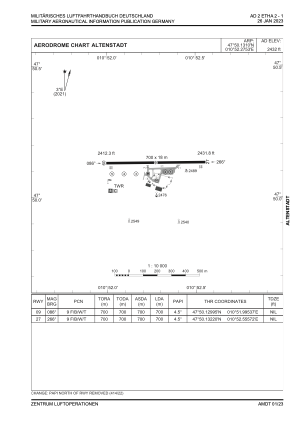


ETHA - Altenstadt
Located in Altenstadt, Germany
ICAO - ETHA, IATA -
Data provided by AirmateGeneral information
Coordinates: N47°50'8" E10°52'17"
Elevation is 2432 feet MSL.
Magnetic variation is 3.8° East View others Airports in Bavaria
Operational data
Special qualification required
Current time UTC:
Current local time:
Weather
METAR: ETHA 270720Z AUTO 35001KT 9999 // ////// 10/02 Q1010 ///
Communications frequencies: [VIEW]
Runways:
| RWY identifier | QFU | Length (ft) | Width (ft) | Surface | LDA (ft) |
| 09 | 90° | 2297 | 59 | ASPH | 2297 |
| 27 | 270° | 2297 | 59 | ASPH | 2297 |
Airport contact information
Address: Altenstadt Germany