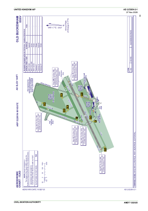


EGSV - Old Buckenham
Located in Norwich City, United Kingdom
ICAO - EGSV, IATA -
Data provided by AirmateGeneral information
Coordinates: N52°29'51" E1°3'7"
Elevation is 194 feet MSL.
View others Airports in England
Operational data
Special qualification required
Current time UTC:
Current local time:
Weather at : EGSH - Norwich ( 25 km )
METAR: EGSH 271920Z 03009KT 7000 -RADZ BKN003 OVC007 08/08 Q1005 TEMPO 4000 RADZ BR
TAF: TAF EGSH 271700Z 2718/2803 03006KT 9999 BKN008 TEMPO 2718/2720 4000 BR BKN003 TEMPO 2720/2803 2000 RADZ BKN003
Communications frequencies: [VIEW]
Runways:
| RWY identifier | QFU | Length (ft) | Width (ft) | Surface | LDA (ft) |
| 02 | 20° | 1404 | 59 | Grass | |
| 20 | 200° | 1404 | 59 | Grass | |
| 07L | 65° | 1548 | 75 | Grass | |
| 25R | 245° | 1548 | 75 | Grass | |
| 07 | 65° | 2618 | 59 | Asphalt | |
| 25 | 245° | 2618 | 59 | Asphalt |
Airport contact information
Address: Norwich City United Kingdom
Other aviation service providers
Flight schools

Old Buckenham Aero Club Limited
Old Buckenham Aero Club Limited
flyingoldbuck@gmail.com+44 01953861337