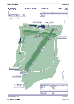


EGSG - Stapleford
Located in Romford, United Kingdom
ICAO - EGSG, IATA -
Data provided by AirmateGeneral information
Coordinates: N51°39'9" E0°9'22"
Elevation is 185 feet MSL.
View others Airports in England
Operational data
Special qualification required
Current time UTC:
Current local time:
Weather at : EGLC - London/City ( 18 km )
METAR: EGLC 281020Z AUTO 26014KT 9999 BKN015 OVC021 08/05 Q1003
TAF: TAF EGLC 280802Z 2809/2818 29010KT 9999 SCT007 OVC020 TEMPO 2809/2811 4000 RADZ BKN006 BECMG 2811/2814 BKN014 BECMG 2815/2818 22009KT SCT035
Communications frequencies: [VIEW]
Runways:
| RWY identifier | QFU | Length (ft) | Width (ft) | Surface | LDA (ft) |
| 03R | 36° | 3533 | 151 | UNK | |
| 21L | 216° | 3533 | 151 | UNK | |
| 03L | 35° | 2953 | 98 | UNK | |
| 21R | 216° | 2953 | 98 | UNK |
Airport contact information
Address: Romford United Kingdom
Other aviation service providers
Flight schools

Stapleford Flying Club Limited T/A Stapleford Flight Centre
Stapleford Flying Club Limited T/A Stapleford Flight Centre
lauraward@flysfc.com+44 01708688380