


EGLD - Denham
Located in Gerrards Cross, United Kingdom
ICAO - EGLD, IATA -
Data provided by AirmateGeneral information
Coordinates: N51°35'18" W0°30'47"
Elevation is 249 feet MSL.
View others Airports in England
Operational data
Special qualification required
Current time UTC:
Current local time:
Weather at : EGWU - Northolt ( 8 km )
METAR: EGWU 281620Z 25008KT 9999 SCT039 BKN060 12/03 Q1009 NOSIG RMK BLU BLU
TAF: TAF EGWU 281616Z 2818/2912 22007KT 9999 SCT045 PROB30 TEMPO 2818/2820 6000 SHRA PROB30 TEMPO 2807/2809 SCT024 PROB40 TEMPO 2810/2812 20015G25KT
Communications frequencies: [VIEW]
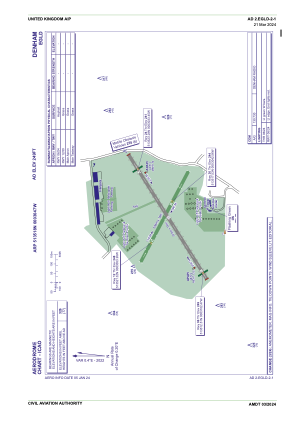
Runways:
| RWY identifier | QFU | Length (ft) | Width (ft) | Surface | LDA (ft) |
| 12 | 118° | 1791 | 59 | Grass | |
| 30 | 298° | 1791 | 59 | Grass | |
| 06 | 59° | 2543 | 59 | asphalt | |
| 24 | 239° | 2543 | 59 | asphalt |
Airport contact information
Address: Gerrards Cross United Kingdom
