


EGHH - Bournemouth
Located in Bournemouth, United Kingdom
ICAO - EGHH, IATA - BOH
Data provided by AirmateGeneral information
Coordinates: N50°46'48" W1°50'33"
Elevation is 38 feet MSL.
View others Airports in England
Operational data
Special qualification required
Current time UTC:
Current local time:
Weather
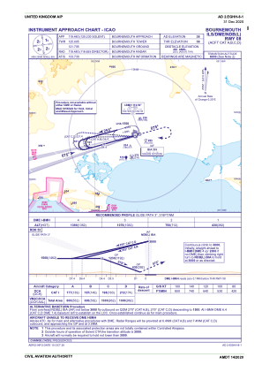
METAR: EGHH 271350Z 07010KT 9999 SCT020 BKN025 12/08 Q1001
TAF: TAF EGHH 271358Z 2715/2724 02010KT 9999 SCT016 BKN035 PROB30 TEMPO 2715/2716 14008KT 7000 SHRA BKN012 TEMPO 2716/2724 4000 RADZ BKN012 PROB30 TEMPO 2717/2724 +RA BKN006
Communications frequencies: [VIEW]
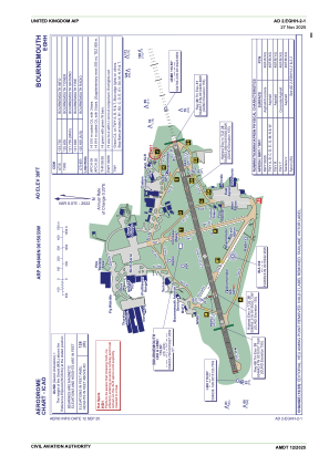
Runways:
| RWY identifier | QFU | Length (ft) | Width (ft) | Surface | LDA (ft) |
| 08 | 75° | 7454 | 151 | ASP | |
| 26 | 255° | 7454 | 151 | ASP | |
| 26X | 255° | 0 | 0 | UNK |
Airport contact information
Address: Bournemouth United Kingdom
Handlers

Other aviation service providers
Flight schools

Bournemouth Flying Club Limited T/A Bournemouth Commercial Flight Training Centre
Bournemouth Flying Club Limited T/A Bournemouth Commercial Flight Training Centre
info@apacademy.aero+44 01202596955