


EERA - Rapla
Located in Rapla, Estonia
ICAO - EERA, IATA -
Data provided by AirmateGeneral information
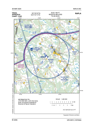
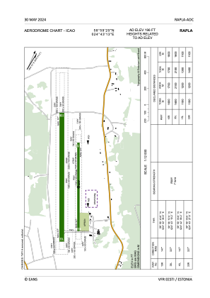
Coordinates: N58°59'20" E24°43'13"
Elevation is 196 feet MSL.
Magnetic variation is 9° East View others Airports in Rapla County
Operational data
Special qualification required
Current time UTC:
Current local time:
Weather at : EEEI - Amari ( 42 km )
METAR: EEEI 211250Z 03011KT 350V070 CAVOK 18/03 Q1023 NOSIG
TAF: TAF EEEI 211130Z 2112/2212 03012KT CAVOK BECMG 2120/2122 09008KT
Communications frequencies: [VIEW]
Runways:
| RWY identifier | QFU | Length (ft) | Width (ft) | Surface | LDA (ft) |
| 15R | 0° | 5249 | 197 | UNK | |
| 33L | 0° | 5249 | 197 | UNK | |
| 15L | 0° | 3609 | 98 | UNK | |
| 33R | 0° | 3609 | 98 | UNK |
Airport contact information
Address: Rapla Estonia