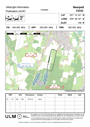


EBNE - Neerpelt
Located in Neerpelt, Belgium
ICAO - EBNE, IATA -
Data provided by AirmateGeneral information
Coordinates: N51°12'43" E5°28'43"
Elevation is 140 feet MSL.
Magnetic variation is 2° East View others Airports in Limburg
Operational data
Special qualification required
Current time UTC:
Current local time:
Weather at : EBBL - Kleine-Brogel ( 5 km )
TAF: TAF EBBL 211141Z 2113/2122 23008KT 9999 FEW035 BKN120 TEMPO 2113/2122 5000 -SHRA SCT025TCU TEMPO 2114/2120 4000 SHRA FEW012 BKN022TCU TEMPO 2114/2120 23010G20KT 3000 TSRA SCT012 BKN018CB BECMG 2119/2121 5000 BR SCT006 BKN010 TEMPO 2120/2122 3000 -RADZ SCT002 BKN005
Communications frequencies: [VIEW]
Runways:
Airport contact information
Address: Neerpelt Belgium