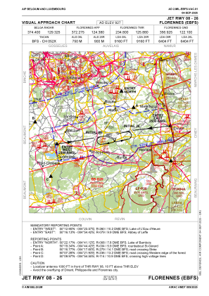
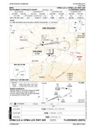
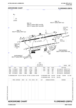


EBFS - Florennes
Located in Florennes, Belgium
ICAO - EBFS, IATA -
Data provided by AirmateGeneral information
Coordinates: N50°14'36" E4°38'45"
Elevation is 927 feet MSL.
Magnetic variation is 2° East View others Airports in Namur
Operational data
Special qualification required
Current time UTC:
Current local time:
Weather
METAR: EBFS 152325Z AUTO 08003KT 9999 BKN047/// BKN090/// 13/13 Q1006 BLU
TAF: TAF AMD EBFS 152015Z 1519/1607 09004KT 9999 FEW020 BKN150 1519/1607 VRB02KT BECMG 1520/1522 BKN020 SCT070 BKN180 TEMPO 1600/1604 2000 TSRA SHRA BKN014CB BKN018 BKN050 BECMG 1604/1606 4000 -RA BKN003 BKN010 OVC015 TEMPO 1604/1607 3000 -SHRA BKN001 BKN010TCU OVC012
Communications frequencies: [VIEW]
Runways:
| RWY identifier | QFU | Length (ft) | Width (ft) | Surface | LDA (ft) |
| 08L | 80° | 11115 | 148 | ASPH | 8648 |
| 26R | 260° | 11115 | 148 | ASPH | 8763 |
| 08R | 80° | 7375 | 75 | ASPH | 5965 |
| 26L | 260° | 7375 | 75 | ASPH | 6027 |
Airport contact information
Address: Florennes Belgium
Other aviation service providers
Aviation club (not for profit)

Royal Belgian Defence Aeroclub
Royal Belgian Defence Aeroclub
comopsair-avia-secretariaat@mil.be+3224419073