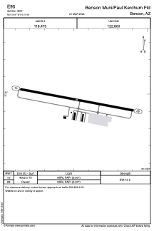


E95 - Benson Muni/Paul Kerchum Fld
Located in Benson, United States
ICAO - E95, IATA -
Data provided by AirmateGeneral information
Coordinates: N31°59'58" W110°21'29"
Elevation is 3831 feet MSL.
Magnetic variation is 12° East View others Airports in Arizona
Operational data
Special qualification required
Current time UTC:
Current local time:
Weather at : KFHU - Sierra Vista Muni-Libby Aaf ( 46 km )
METAR: KFHU 140755Z AUTO 29007KT 10SM CLR 20/M01 A3001 RMK AO2 SLP098 T01971014
TAF: TAF KFHU 140350Z 1404/1510 23009KT 9999 FEW120 SCT200 QNH2999INS WND VRB06KT AFT 1409 BECMG 1417/1418 12012KT 9999 FEW100 QNH2996INS BECMG 1419/1420 23014G22KT 9999 SCT120 510007 QNH2988INS BECMG 1501/1502 23009KT 9999 FEW120 QNH2990INS BECMG 1508/1509 VRB06KT 9999 SKC QNH2996INS TX29/1420Z TN13/1412Z
Communications frequencies: [VIEW]
Runways:
| RWY identifier | QFU | Length (ft) | Width (ft) | Surface | LDA (ft) |
| 10 | 101° | 4002 | 75 | ASPH | |
| 28 | 281° | 4002 | 75 | ASPH |
Airport contact information
Address: Benson United States
Other aviation service providers
Flight schools

Southwestern Aviation, Llc
Southwestern Aviation, Llc
royfjones@southwesternaviation.com+1(520)586-3262