


CYXH - Medicine Hat
Located in , Canada
ICAO - CYXH, IATA - YXH
Data provided by AirmateGeneral information
Coordinates: N50°1'8" W110°43'14"
Elevation is 2351 feet MSL.
Magnetic variation is 12.9367° East View others Airports in Alberta
Operational data
Special qualification required
Current time UTC:
Current local time:
Weather
METAR: CYXH 032300Z 33007KT 300V050 30SM BKN048 10/M02 A3001 RMK CU5 SLP184
TAF: TAF CYXH 031740Z 0318/0406 30008KT P6SM SCT020 BKN040 TEMPO 0318/0319 BKN020 OVC040 FM031900 33010KT P6SM BKN040 TEMPO 0319/0404 SCT040 BECMG 0323/0401 18008KT FM040400 18008KT P6SM SKC RMK NXT FCST BY 040000Z
Communications frequencies: [VIEW]
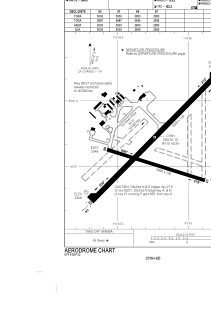
Runways:
| RWY identifier | QFU | Length (ft) | Width (ft) | Surface | LDA (ft) |
| 09 | 107° | 2850 | 100 | ASPH | 2850 |
| 27 | 287° | 2850 | 100 | ASPH | 2850 |
| 03 | 45° | 5003 | 150 | ASPH | 5003 |
| 21 | 225° | 5003 | 150 | ASPH | 5003 |
Airport contact information
Address: Canada
