


CYTH - Thompson
Located in , Canada
ICAO - CYTH, IATA - YTH
Data provided by AirmateGeneral information
Coordinates: N55°48'17" W97°51'45"
Elevation is 735 feet MSL.
Magnetic variation is 2.845° East View others Airports in Manitoba
Operational data
Special qualification required
Current time UTC:
Current local time:
Weather
METAR: CYTH 162000Z 01009KT 330V040 15SM FEW032 SCT078 BKN120 15/07 A2971 RMK CU1AC3AC2 SLP073 DENSITY ALT 1200FT
TAF: TAF CYTH 161840Z 1619/1707 VRB03KT P6SM SCT030 BKN120 TEMPO 1619/1621 P6SM -SHRA FEW008 BKN030 OVC080 FM162100 04008KT P6SM -SHRA SCT015 OVC025 TEMPO 1621/1624 3SM -SHRA BR SCT008 OVC015 FM170000 02010KT 6SM -SHRA BR SCT008 OVC020 TEMPO 1700/1707 3SM -SHRA BR BKN008 OVC020 BECMG 1702/1704 06006KT RMK NXT FCST BY 170100Z
Communications frequencies: [VIEW]
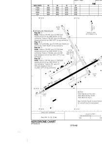
Runways:
| RWY identifier | QFU | Length (ft) | Width (ft) | Surface | LDA (ft) |
| 06 | 61° | 5800 | 150 | ASPH | 5800 |
| 24 | 241° | 5800 | 150 | ASPH | 5800 |
| 15 | 151° | 5079 | 100 | GRAVE | 5079 |
| 33 | 331° | 5079 | 100 | GRAVE | 5079 |
Airport contact information
Address: Canada