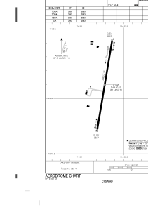


CYSW - Elk Valley
Located in Sparwood, Canada
ICAO - CYSW, IATA -
Data provided by AirmateGeneral information
Coordinates: N49°50'0" W114°53'4"
Elevation is 3800 feet MSL.
Magnetic variation is 14.9667° East View others Airports in British Columbia
Operational data
Special qualification required
Current time UTC:
Current local time:
Weather at : CYXC - Canadian Rockies Intl ( 69 km )
METAR: CYXC 281500Z 19010KT 45SM FEW040 FEW060 SCT100 SCT210 09/02 A2988 RMK SC1SC1AC1CI1 SLP132
TAF: TAF CYXC 281240Z 2813/2901 19007KT P6SM SCT040 BKN070 TEMPO 2813/2901 P6SM -SHRA BKN030 RMK NXT FCST BY 281900Z
Communications frequencies: [VIEW]
Runways:
| RWY identifier | QFU | Length (ft) | Width (ft) | Surface | LDA (ft) |
| 17 | 0° | 4000 | 75 | ASPH | |
| 35 | 0° | 4000 | 75 | ASPH |
Airport contact information
Address: Sparwood Canada