


CYRC - St-Honore
Located in Chicoutimi, Canada
ICAO - CYRC, IATA -
Data provided by AirmateGeneral information
Coordinates: N48°31'15" W71°3'2"
Elevation is 544 feet MSL.
Magnetic variation is -17.1633° East View others Airports in Quebec
Operational data
Special qualification required
Current time UTC:
Current local time:
Weather at : CYBG - Bagotville ( 22 km )
METAR: CYBG 090100Z 10008KT 25SM BKN064 09/01 A2975 RMK SC7 DENSITY ALT 157FT SLP079
TAF: TAF CYBG 082340Z 0900/0924 10010KT P6SM BKN070 BKN150 FM090600 VRB03KT P6SM FEW020 OVC040 FM091400 08005KT P6SM SCT040 OVC070 BECMG 0916/0918 08010G20KT BECMG 0921/0923 VRB03KT RMK NXT FCST BY 090300Z
Communications frequencies: [VIEW]
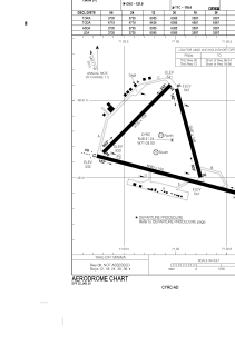
Runways:
| RWY identifier | QFU | Length (ft) | Width (ft) | Surface | LDA (ft) |
| 12 | 105° | 6085 | 150 | ASPH | 6085 |
| 30 | 285° | 6085 | 150 | ASPH | 6085 |
| 06 | 45° | 3735 | 148 | ASPH | 3735 |
| 24 | 225° | 3735 | 148 | ASPH | 3735 |
| 18 | 165° | 3597 | 148 | ASPH | 3597 |
| 36 | 345° | 3597 | 148 | ASPH | 3597 |
Airport contact information
Address: Chicoutimi Canada
Other aviation service providers
Flight schools

Centre Québécois De Formation Aéronautique
Centre Québécois De Formation Aéronautique
cqfa@cqfa.ca+14186733421
Aviation club (not for profit)

C.V.V.S (Centre Vol à Voile Saguenay)
C.V.V.S (Centre Vol à Voile Saguenay)
volavoilesaguenay@gmail.com18558470154
Non aviation service providers
Restaurant

Association des pilotes du Saguenay Lac St-Jean
Association des pilotes du Saguenay Lac St-Jean
jaclaberge@hotmail.com5812357474