


CYJN - St-Jean
Located in St Jean, Canada
ICAO - CYJN, IATA - YJN
Data provided by AirmateGeneral information
Coordinates: N45°17'40" W73°16'54"
Elevation is 136 feet MSL.
Magnetic variation is -14.90° East View others Airports in Quebec
Operational data
Special qualification required
Current time UTC:
Current local time:
Weather at : CYHU - St-Hubert ( 27 km )
METAR: CYHU 060813Z AUTO 19006KT 3SM -RA BR OVC003 10/10 A2996 RMK SLP148
TAF: TAF CYHU 060540Z 0606/0706 18008KT 1 1/2SM -DZ -RA BR OVC006 TEMPO 0606/0610 6SM BR OVC010 FM061000 20006KT 4SM -DZ BR OVC006 TEMPO 0610/0613 P6SM NSW OVC012 PROB30 0610/0613 OVC005 FM061300 23007KT P6SM BKN006 OVC020 TEMPO 0613/0615 SCT006 BKN040 FM061500 24008KT P6SM SCT020 TEMPO 0615/0618 BKN020 FM061800 24010KT P6SM SCT050 BECMG 0618/0620 24015KT FM062300 28010KT P6SM FEW060 BECMG 0700/0702 33006KT RMK FCST BASED ON AUTO OBS. NXT FCST BY 061200Z
Communications frequencies: [VIEW]
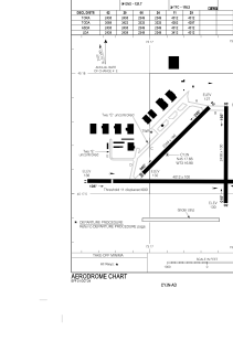
Runways:
| RWY identifier | QFU | Length (ft) | Width (ft) | Surface | LDA (ft) |
| 02 | 0° | 2438 | 100 | ASPH | 2438 |
| 20 | 180° | 2438 | 100 | ASPH | 2438 |
| 06 | 45° | 2349 | 100 | ASPH | 2349 |
| 24 | 225° | 2349 | 100 | ASPH | 2349 |
| 11 | 90° | 4012 | 100 | ASPH | 3412 |
| 29 | 270° | 4012 | 100 | ASPH | 4012 |
Airport contact information
Address: St Jean Canada