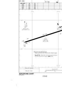


CYCQ - Chetwynd
Located in , Canada
ICAO - CYCQ, IATA - YCQ
Data provided by AirmateGeneral information
Coordinates: N55°41'14" W121°37'36"
Elevation is 1999 feet MSL.
Magnetic variation is 18.6175° East View others Airports in British Columbia
Operational data
Special qualification required
Current time UTC:
Current local time:
Weather
METAR: CYCQ 240100Z 22006KT 190V250 35SM FEW050 SCT055 SCT130 BKN220 21/M02 A2969 RMK SC2SC1AC1CI2 PCPN DIST SE VIRGA NE+NW ROTOR CLD S-SW DIST FU VLY W LAST STFD OBS/NXT 241300Z SLP068 DENSITY ALT 3500FT
Communications frequencies: [VIEW]
Runways:
| RWY identifier | QFU | Length (ft) | Width (ft) | Surface | LDA (ft) |
| 05 | 72° | 4481 | 100 | ASPH | 4481 |
| 23 | 252° | 4481 | 100 | ASPH | 4481 |
Airport contact information
Address: Canada