


CYCG - West Kootenay Regional
Located in Castlegar, Canada
ICAO - CYCG, IATA - YCG
Data provided by AirmateGeneral information
Coordinates: N49°17'46" W117°37'57"
Elevation is 1626 feet MSL.
Magnetic variation is 15.3333° East View others Airports in British Columbia
Operational data
Special qualification required
Current time UTC:
Current local time:
Weather
METAR: CYCG 281700Z 17011KT 15SM FEW029 BKN043 OVC064 09/07 A2994 RMK SC1SC7SC1 SC TR SLP149
TAF: TAF CYCG 281440Z 2815/2903 15008KT P6SM FEW006 SCT040 BKN080 FM282000 20010KT P6SM -SHRA FEW025 BKN050 RMK NXT FCST BY 281900Z
Communications frequencies: [VIEW]
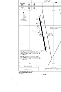
Runways:
| RWY identifier | QFU | Length (ft) | Width (ft) | Surface | LDA (ft) |
| 15 | 169° | 5299 | 150 | ASPH | 5299 |
| 33 | 349° | 5299 | 150 | ASPH | 5299 |
Airport contact information
Address: Castlegar Canada