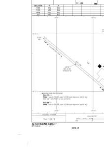


CET9 - Jean Marie River
Located in Jean Marie River, Canada
ICAO - CET9, IATA -
Data provided by AirmateGeneral information
Coordinates: N61°31'21" W120°37'30"
Elevation is 457 feet MSL.
Magnetic variation is 19.3500° East View others Airports in Northwest Territories
Operational data
Special qualification required
Current time UTC:
Current local time:
Weather at : CYFS - Fort Simpson ( 42 km )
METAR: CYFS 171100Z 10004KT 070V140 15SM SCT079 BKN120 BKN210 BKN250 05/M02 A2983 RMK AC4AC1CI1CI1 CI TR SLP109
TAF: TAF CYFS 171140Z 1712/1724 11005KT P6SM SCT080 BKN140 FM171800 12005KT P6SM BKN080 TEMPO 1718/1724 P6SM -SHRA VCTS BKN060CB RMK NXT FCST BY 171800Z
Communications frequencies: [VIEW]
Runways:
| RWY identifier | QFU | Length (ft) | Width (ft) | Surface | LDA (ft) |
| 11 | 130° | 2512 | 59 | GRAVE | 2512 |
| 29 | 310° | 2512 | 59 | GRAVE | 2512 |
Airport contact information
Address: Jean Marie River Canada