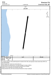


B10 - Bowman Fld
Located in Livermore Falls, United States
ICAO - B10, IATA -
Data provided by AirmateGeneral information
Coordinates: N44°24'36" W70°8'46"
Elevation is 324 feet MSL.
Magnetic variation is -18° East View others Airports in Maine
Operational data
Special qualification required
Current time UTC:
Current local time:
Weather at : KAUG - Augusta State ( 29 km )
METAR: KAUG 151353Z AUTO VRB04KT 10SM CLR 18/12 A2989 RMK AO2 SLP121 T01830122
TAF: KAUG 151128Z 1512/1612 VRB04KT P6SM SCT015 BKN250 FM151700 20009KT P6SM VCSH SCT040 BKN070 BKN250 FM160000 20004KT P6SM VCSH FEW015 BKN070 OVC100 FM160700 VRB03KT 3SM BR SCT006 BKN015 FM160900 VRB03KT 1SM BR BKN006
Communications frequencies: [VIEW]
Runways:
| RWY identifier | QFU | Length (ft) | Width (ft) | Surface | LDA (ft) |
| 02 | 8° | 2201 | 120 | GRASS | |
| 20 | 188° | 2201 | 120 | GRASS |
Airport contact information
Address: Livermore Falls United States