


AYPY - Port Moresby
Located in Port Moresby, Papua New Guinea
ICAO - AYPY, IATA - POM
Data provided by AirmateGeneral information
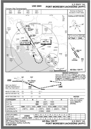
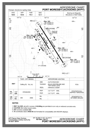
Coordinates: S9°26'25" E147°13'7"
Elevation is 129 feet MSL.
View others Airports in National Capital District (Port Moresby)
Operational data
Special qualification required
Current time UTC:
Current local time:
Weather
METAR: AYPY 290400Z 16010G15KT 9999 FUHZ FEW025 SCT030 32/26 Q1006 RMK/ CB FM NW TO E
TAF: TAF AYPY 282245Z 2900/2924 14010KT 9999 SCT020 FM290400 15008KT 9999 SCT020 SCT140 FM290500 15015KT 9999 SCT020 BKN140 INTER 2906/2909 5000 TSRA BKN008 FEW018CB
Communications frequencies: [VIEW]
Runways:
| RWY identifier | QFU | Length (ft) | Width (ft) | Surface | LDA (ft) |
| 14R | 148° | 4265 | 98 | ASP | |
| 32L | 328° | 4265 | 98 | ASP | |
| 14L | 148° | 9022 | 148 | ASP | |
| 32R | 328° | 9022 | 148 | ASP |
Airport contact information
Address: Port Moresby Papua New Guinea