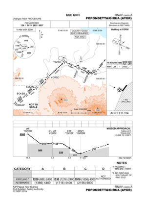
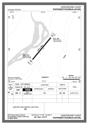


AYGR - Girua
Located in Popondetta, Papua New Guinea
ICAO - AYGR, IATA - PNP
Data provided by AirmateGeneral information
Coordinates: S8°48'32" E148°18'23"
Elevation is 334 feet MSL.
View others Airports in Northern (Oro)
Operational data
Special qualification required
Current time UTC:
Current local time:
Weather at : - ( 0 km )
METAR: PAJC 090857Z AUTO 11008G16KT 050V210 3SM -SN SCT010 BKN016 OVC023 01/M03 A2979 RMK AO2 RAB00E32UPB32E51SNE00B51 SLP087 P0000 60002 T00111033 400390000 58006 FZRANO $
Communications frequencies: [VIEW]
Runways:
| RWY identifier | QFU | Length (ft) | Width (ft) | Surface | LDA (ft) |
| 03 | 30° | 5495 | 98 | ASP | |
| 21 | 210° | 5495 | 98 | ASP |
Airport contact information
Address: Popondetta Papua New Guinea