


97M - Ekalaka
Located in Ekalaka, United States
ICAO - 97M, IATA -
Data provided by AirmateGeneral information
Coordinates: N45°52'35" W104°32'15"
Elevation is 3504 feet MSL.
Magnetic variation is 12° East View others Airports in Montana
Operational data
Special qualification required
Current time UTC:
Current local time:
Weather at : KBHK - Baker Muni ( 57 km )
METAR: KBHK 021951Z AUTO 30021G30KT 10SM -RA FEW014 OVC039 06/02 A2978 RMK AO2 PK WND 25031/1852 RAB33 SLP104 P0000 T00610022
Communications frequencies: [VIEW]
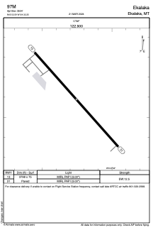
Runways:
| RWY identifier | QFU | Length (ft) | Width (ft) | Surface | LDA (ft) |
| 13 | 138° | 3798 | 75 | ASPH | |
| 31 | 318° | 3798 | 75 | ASPH |
Airport contact information
Address: Ekalaka United States