


95KS - Fuller Airfield
Located in Maple Hill, United States
ICAO - 95KS, IATA -
Data provided by AirmateGeneral information
Coordinates: N39°1'34" W96°0'54"
Elevation is 1058 feet MSL.
View others Airports in Kansas
Operational data
Special qualification required
Current time UTC:
Current local time:
Weather at : KFOE - Topeka Rgnl ( 31 km )
METAR: KFOE 191153Z 00000KT 10SM CLR 17/14 A2999 RMK AO2 SLP147 T01720144 10217 20167 53015
TAF: KFOE 191120Z 1912/2012 13006KT P6SM SKC FM191800 17014G22KT P6SM SCT050 FM200300 24014G30KT 3SM TSRA BKN035CB FM200500 17008KT P6SM SCT060
Communications frequencies: [VIEW]
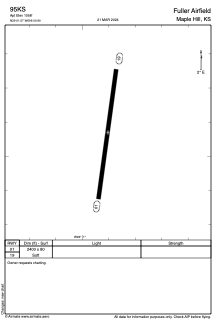
Runways:
| RWY identifier | QFU | Length (ft) | Width (ft) | Surface | LDA (ft) |
| 01 | 0° | 2400 | 80 | GRASS | |
| 19 | 0° | 2400 | 80 | GRASS |
Airport contact information
Address: Maple Hill United States