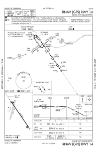
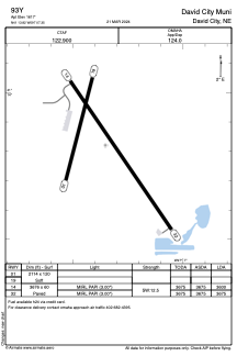


93Y - David City Muni
Located in David City, United States
ICAO - 93Y, IATA -
Data provided by AirmateGeneral information
Coordinates: N41°13'49" W97°7'21"
Elevation is 1617 feet MSL.
Magnetic variation is 05° East View others Airports in Nebraska
Operational data
Special qualification required
Current time UTC:
Current local time:
Weather at : KOLU - Columbus Muni ( 30 km )
METAR: KOLU 291156Z AUTO 25004KT 10SM CLR 05/03 A2988 RMK AO2 SLP125 70013 T00500033 10089 20044 53009
Communications frequencies: [VIEW]
Runways:
| RWY identifier | QFU | Length (ft) | Width (ft) | Surface | LDA (ft) |
| 01 | 15° | 2114 | 120 | GRASS | |
| 19 | 195° | 2114 | 120 | GRASS | |
| 14 | 146° | 3676 | 60 | ASPH | 3600 |
| 32 | 326° | 3676 | 60 | ASPH | 3675 |
Airport contact information
Address: David City United States