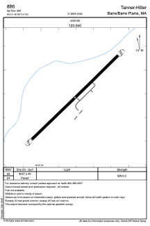


8B5 - Tanner-Hiller
Located in Barre/Barre Plains, United States
ICAO - 8B5, IATA -
Data provided by AirmateGeneral information
Coordinates: N42°21'23" W72°7'48"
Elevation is 589 feet MSL.
Magnetic variation is -15° East View others Airports in Massachusetts
Operational data
Special qualification required
Current time UTC:
Current local time:
Weather at : KORH - Worcester Rgnl ( 23 km )
METAR: KORH 161454Z 06011G21KT 7SM -RA BKN004 BKN009 OVC031 13/12 A2983 RMK AO2 CIG 002V006 SLP101 P0005 60023 T01330117 53010
TAF: KORH 161431Z 1615/1712 06011G24KT 3SM -RA BR OVC004 FM162200 05010G22KT 6SM BR VCSH OVC010 FM170200 05007KT P6SM BKN008 FM170400 04007KT P6SM BKN003
Communications frequencies: [VIEW]
Runways:
| RWY identifier | QFU | Length (ft) | Width (ft) | Surface | LDA (ft) |
| 06 | 0° | 3027 | 40 | ASPH | |
| 24 | 0° | 3027 | 40 | ASPH |
Airport contact information
Address: Barre/Barre Plains United States