


83K - Harris
Located in Fort Ann, United States
ICAO - 83K, IATA -
Data provided by AirmateGeneral information
Coordinates: N43°24'35" W73°31'58"
Elevation is 261 feet MSL.
View others Airports in New York
Operational data
Special qualification required
Current time UTC:
Current local time:
Weather at : KGFL - Floyd Bennett Meml ( 10 km )
METAR: KGFL 241753Z AUTO 28010G21KT 10SM BKN090 24/08 A2974 RMK AO2 SLP071 T02440078 10261 20161 56009
TAF: KGFL 241721Z 2418/2518 28015G28KT P6SM SCT080 SCT250 FM242300 31008KT P6SM FEW080 FM250400 VRB03KT P6SM SKC FM250700 00000KT 5SM BR FEW002 FM251100 VRB03KT P6SM SKC FM251500 15005KT P6SM SCT250
Communications frequencies: [VIEW]
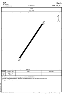
Runways:
| RWY identifier | QFU | Length (ft) | Width (ft) | Surface | LDA (ft) |
| 04 | 34° | 2200 | 50 | GRASS | |
| 22 | 214° | 2200 | 50 | GRASS |
Airport contact information
Address: Fort Ann United States