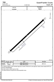


7M5 - Ozark/Franklin County
Located in Ozark, United States
ICAO - 7M5, IATA -
Data provided by AirmateGeneral information
Coordinates: N35°30'39" W93°50'22"
Elevation is 648 feet MSL.
Magnetic variation is 04° East View others Airports in Arkansas
Operational data
Special qualification required
Current time UTC:
Current local time:
Weather at : KFSM - Fort Smith Rgnl ( 52 km )
METAR: KFSM 272153Z 13006G16KT 10SM BKN047 BKN060 OVC095 26/19 A2984 RMK AO2 SLP100 T02560194
TAF: KFSM 271739Z 2718/2818 19010G22KT P6SM BKN035 TEMPO 2718/2721 BKN025 FM272100 19012G20KT P6SM VCTS BKN050CB FM280100 17010G20KT P6SM BKN040 WS020/16050KT FM281000 14012G22KT 5SM -TSRA BKN025CB TEMPO 2810/2813 VRB25G35KT 3SM TSRA OVC015CB FM281400 14010KT P6SM VCSH OVC035 FM281600 16008KT P6SM BKN040
Communications frequencies: [VIEW]
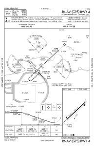
Runways:
| RWY identifier | QFU | Length (ft) | Width (ft) | Surface | LDA (ft) |
| 04 | 47° | 3302 | 75 | ASPH | |
| 22 | 227° | 3302 | 75 | ASPH |
Airport contact information
Address: Ozark United States