


69K - Wamego Muni
Located in Wamego, United States
ICAO - 69K, IATA -
Data provided by AirmateGeneral information
Coordinates: N39°11'52" W96°15'32"
Elevation is 966 feet MSL.
Magnetic variation is 06° East View others Airports in Kansas
Operational data
Special qualification required
Current time UTC:
Current local time:
Weather at : KMHK - Manhattan Rgnl ( 36 km )
METAR: KMHK 190152Z 01003KT 10SM CLR 24/17 A2987 RMK AO2 SLP105 T02440167 $
TAF: KMHK 182336Z 1900/1924 06003KT P6SM SKC FM191700 16015G23KT P6SM FEW060
Communications frequencies: [VIEW]
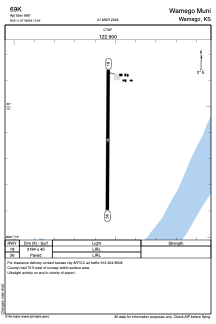
Runways:
| RWY identifier | QFU | Length (ft) | Width (ft) | Surface | LDA (ft) |
| 18 | 0° | 3184 | 45 | ASPH | |
| 36 | 0° | 3184 | 45 | ASPH |
Airport contact information
Address: Wamego United States