


5T4 - Herreid Muni
Located in Herreid, United States
ICAO - 5T4, IATA -
Data provided by AirmateGeneral information
Coordinates: N45°50'54" W100°4'26"
Elevation is 1725 feet MSL.
Magnetic variation is 09° East View others Airports in South Dakota
Operational data
Special qualification required
Current time UTC:
Current local time:
Weather at : KMBG - Mobridge Muni ( 42 km )
METAR: KMBG 151952Z AUTO 33010G16KT 10SM SCT018 OVC032 14/09 A2983 RMK AO2 SLP101 T01390094
TAF: KMBG 151732Z 1518/1618 33013G19KT P6SM BKN028 FM152100 33013KT P6SM BKN035 FM160000 31009KT P6SM FEW120 FM160300 VRB05KT P6SM FEW250 FM161600 22008KT P6SM SCT250
Communications frequencies: [VIEW]
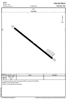
Runways:
| RWY identifier | QFU | Length (ft) | Width (ft) | Surface | LDA (ft) |
| 12 | 128° | 2230 | 200 | OTHER | |
| 30 | 308° | 2230 | 200 | OTHER |
Airport contact information
Address: Herreid United States