


4O1 - Snyder
Located in Snyder, United States
ICAO - 4O1, IATA -
Data provided by AirmateGeneral information
Coordinates: N34°37'40" W99°0'50"
Elevation is 1325 feet MSL.
Magnetic variation is 08° East View others Airports in Oklahoma
Operational data
Special qualification required
Current time UTC:
Current local time:
Weather at : KLTS - Altus Afb ( 24 km )
METAR: KLTS 091855Z AUTO 06018G23KT 10SM BKN070 27/02 A2989 RMK AO2 SLP111 T02730016 $
TAF: TAF KLTS 091700Z 0917/1023 04015G25KT 9999 SCT070 510103 QNH2980INS BECMG 1002/1003 VRB06KT 9999 SKC QNH2990INS BECMG 1013/1014 02010G20KT 9999 SCT100 QNH3005INS BECMG 1020/1021 05012KT 9999 BKN100 QNH3000INS TX27/0921Z TN12/1012Z
Communications frequencies: [VIEW]
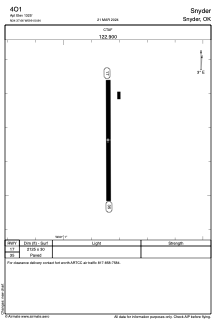
Runways:
| RWY identifier | QFU | Length (ft) | Width (ft) | Surface | LDA (ft) |
| 17 | 179° | 2125 | 30 | ASPH | |
| 35 | 359° | 2125 | 30 | ASPH |
Airport contact information
Address: Snyder United States