


42I - Parr
Located in Zanesville, United States
ICAO - 42I, IATA -
Data provided by AirmateGeneral information
Coordinates: N40°0'26" W82°0'49"
Elevation is 790 feet MSL.
Magnetic variation is -06° East View others Airports in Ohio
Operational data
Special qualification required
Current time UTC:
Current local time:
Weather at : KZZV - Zanesville Muni ( 12 km )
METAR: KZZV 150253Z AUTO 04003KT 10SM BKN070 18/16 A2977 RMK AO2 SLP076 T01780156 58003
TAF: KZZV 142323Z 1500/1524 07003KT P6SM OVC035 FM150500 10003KT P6SM VCSH OVC025 FM150800 06003KT P6SM -SHRA OVC015 TEMPO 1509/1513 4SM -SHRA BKN008 FM151800 02006KT P6SM VCSH OVC025 PROB30 1519/1523 4SM TSRA BKN020CB FM152300 01005KT P6SM VCSH BKN035
Communications frequencies: [VIEW]
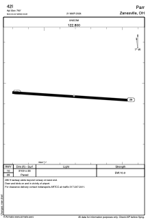
Runways:
| RWY identifier | QFU | Length (ft) | Width (ft) | Surface | LDA (ft) |
| 10 | 94° | 3100 | 26 | ASPH | |
| 28 | 274° | 3100 | 26 | ASPH |
Airport contact information
Address: Zanesville United States
