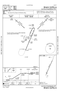
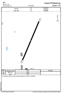


3I7 - Dayton/Phillipsburg
Located in Dayton, United States
ICAO - 3I7, IATA -
Data provided by AirmateGeneral information
Coordinates: N39°54'48" W84°24'1"
Elevation is 1028 feet MSL.
Magnetic variation is -04° East View others Airports in Ohio
Operational data
Special qualification required
Current time UTC:
Current local time:
Weather at : KDAY - James M Cox Dayton Intl ( 15 km )
METAR: KDAY 150856Z 07007KT 6SM BR BKN007 OVC035 17/17 A2969 RMK AO2 SLP048 VCSH 60001 T01670167 56013
TAF: KDAY 150741Z 1508/1606 08006KT 5SM BR VCSH BKN005 BKN027 OVC090 FM151200 05007KT 6SM BR VCSH BKN015 FM151800 02007KT 6SM -SHRA BR VCTS BKN025CB FM152100 02008KT P6SM VCSH BKN050 FM160100 02006KT P6SM VCSH OVC025
Communications frequencies: [VIEW]
Runways:
| RWY identifier | QFU | Length (ft) | Width (ft) | Surface | LDA (ft) |
| 03 | 24° | 3000 | 40 | ASPH | |
| 21 | 204° | 3000 | 40 | ASPH |
Airport contact information
Address: Dayton United States
