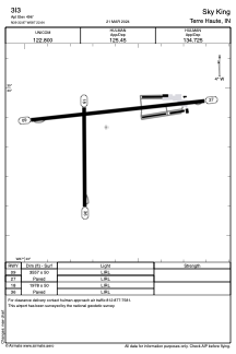


3I3 - Sky King
Located in Terre Haute, United States
ICAO - 3I3, IATA -
Data provided by AirmateGeneral information
Coordinates: N39°32'52" W87°22'38"
Elevation is 496 feet MSL.
Magnetic variation is -04° East View others Airports in Indiana
Operational data
Special qualification required
Current time UTC:
Current local time:
Weather at : KHUF - Terre Haute Rgnl ( 12 km )
METAR: KHUF 060953Z 04004KT 10SM BKN060 OVC070 16/13 A2995 RMK AO2 SLP138 T01560128
TAF: KHUF 060520Z 0606/0706 05006KT P6SM BKN200 FM060800 05006KT P6SM VCSH OVC080 FM061600 11008KT 6SM -SHRA BR OVC028 FM062000 11009KT 6SM BR VCSH OVC029 FM062100 09009KT P6SM VCTS OVC029CB FM070100 10008KT P6SM BKN045
Communications frequencies: [VIEW]
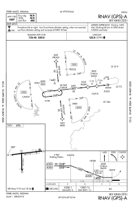
Runways:
| RWY identifier | QFU | Length (ft) | Width (ft) | Surface | LDA (ft) |
| 09 | 84° | 3557 | 50 | ASPH | |
| 27 | 264° | 3557 | 50 | ASPH | |
| 18 | 179° | 1978 | 50 | ASPH | |
| 36 | 359° | 1978 | 50 | ASPH |
Airport contact information
Address: Terre Haute United States
