


2D7 - Beach City
Located in Beach City, United States
ICAO - 2D7, IATA -
Data provided by AirmateGeneral information
Coordinates: N40°38'47" W81°33'21"
Elevation is 984 feet MSL.
Magnetic variation is -06° East View others Airports in Ohio
Operational data
Special qualification required
Current time UTC:
Current local time:
Weather at : KPHD - Harry Clever Fld ( 23 km )
METAR: KPHD 151153Z AUTO 01003KT 3SM -RA BR FEW006 BKN035 OVC055 16/16 A2973 RMK AO2 RAB31 SLP064 P0002 60002 70002 T01610161 10167 20156 51005
Communications frequencies: [VIEW]
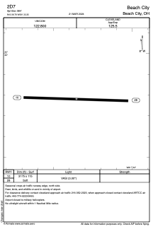
Runways:
| RWY identifier | QFU | Length (ft) | Width (ft) | Surface | LDA (ft) |
| 10 | 92° | 3175 | 115 | GRASS | |
| 28 | 272° | 3175 | 115 | GRASS |
Airport contact information
Address: Beach City United States