


29N - Kroelinger
Located in Vineland, United States
ICAO - 29N, IATA -
Data provided by AirmateGeneral information
Coordinates: N39°31'26" W75°2'47"
Elevation is 93 feet MSL.
Magnetic variation is -10° East View others Airports in New Jersey
Operational data
Special qualification required
Current time UTC:
Current local time:
Weather at : KMIV - Millville Muni ( 17 km )
METAR: KMIV 101054Z AUTO 07010G21KT 10SM OVC014 11/09 A2967 RMK AO2 RAE04 SLP046 P0000 T01110094
TAF: KMIV 100801Z 1008/1106 08012G24KT 5SM BR OVC008 TEMPO 1011/1015 2SM RA BR OVC004 FM102100 06011G21KT 3SM -RA BR OVC008
Communications frequencies: [VIEW]
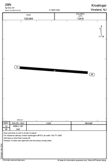
Runways:
| RWY identifier | QFU | Length (ft) | Width (ft) | Surface | LDA (ft) |
| 10 | 96° | 2086 | 190 | GRASS | |
| 28 | 276° | 2086 | 190 | GRASS |
Airport contact information
Address: Vineland United States