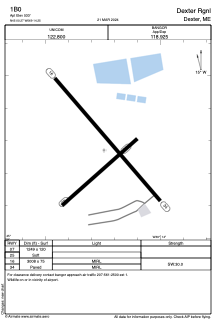


1B0 - Dexter Rgnl
Located in Dexter, United States
ICAO - 1B0, IATA -
Data provided by AirmateGeneral information
Coordinates: N45°0'16" W69°14'15"
Elevation is 533 feet MSL.
Magnetic variation is -18° East View others Airports in Maine
Operational data
Special qualification required
Current time UTC:
Current local time:
Weather at : KBGR - Bangor Intl ( 39 km )
TAF: KBGR 150806Z 1508/1606 18004KT P6SM VCTS BKN040CB FM150900 VRB02KT 2SM BR BKN009 FM151200 VRB02KT P6SM BKN025 FM151500 VRB03KT P6SM SCT045 FM151900 19006KT P6SM VCSH SCT040
Communications frequencies: [VIEW]
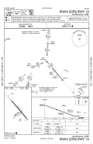
Runways:
| RWY identifier | QFU | Length (ft) | Width (ft) | Surface | LDA (ft) |
| 07 | 49° | 1249 | 120 | GRASS | |
| 25 | 229° | 1249 | 120 | GRASS | |
| 16 | 139° | 3008 | 75 | ASPH | |
| 34 | 319° | 3008 | 75 | ASPH |
Airport contact information
Address: Dexter United States