
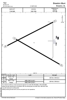


12J - Brewton Muni
Located in Brewton, United States
ICAO - 12J, IATA -
Data provided by AirmateGeneral information
Coordinates: N31°3'3" W87°4'2"
Elevation is 99 feet MSL.
Magnetic variation is -01° East View others Airports in Alabama
Operational data
Special qualification required
Current time UTC:
Current local time:
Weather at : KNSE - Whiting Fld Nas North ( 37 km )
METAR: KNSE 290156Z 14005KT 10SM FEW080 FEW200 19/16 A3009 RMK AO2 SLP176 T01890161 $
TAF: TAF KNSE 2823/2923 17016G22KT 9999 SKC QNH2998INS BECMG 2907/2909 12008KT 9999 SCT015 QNH3000INS BECMG 2915/2917 16012G20KT 9999 SCT050 QNH2999INS TX29/2919Z TN17/2907Z FN00264
Communications frequencies: [VIEW]
Runways:
| RWY identifier | QFU | Length (ft) | Width (ft) | Surface | LDA (ft) |
| 06 | 63° | 5136 | 150 | ASPH | |
| 24 | 243° | 5136 | 150 | ASPH | |
| 12 | 120° | 5001 | 150 | ASPH | |
| 30 | 300° | 5001 | 150 | ASPH |
Airport contact information
Address: Brewton United States