


0S0 - Lind
Located in Lind, United States
ICAO - 0S0, IATA -
Data provided by AirmateGeneral information
Coordinates: N46°58'37" W118°35'14"
Elevation is 1507 feet MSL.
Magnetic variation is 19° East View others Airports in Washington
Operational data
Special qualification required
Current time UTC:
Current local time:
Weather at : KMWH - Grant County Intl ( 61 km )
METAR: KMWH 021952Z 34003KT 10SM CLR 17/M04 A2999 RMK AO2 SLP156 T01721039
TAF: KMWH 021748Z 0218/0318 05005KT P6SM FEW200 FM022000 23005KT P6SM FEW080 FEW200 FM030600 03005KT P6SM SKC FM031500 12006KT P6SM SCT250
Communications frequencies: [VIEW]
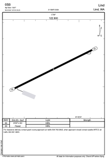
Runways:
| RWY identifier | QFU | Length (ft) | Width (ft) | Surface | LDA (ft) |
| 05 | 64° | 3197 | 50 | ASPH | |
| 23 | 244° | 3197 | 50 | ASPH |
Airport contact information
Address: Lind United States