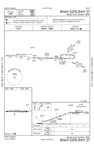
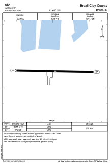


0I2 - Brazil Clay County
Located in Brazil, United States
ICAO - 0I2, IATA -
Data provided by AirmateGeneral information
Coordinates: N39°28'36" W87°5'59"
Elevation is 645 feet MSL.
Magnetic variation is -04° East View others Airports in Indiana
Operational data
Special qualification required
Current time UTC:
Current local time:
Weather at : KHUF - Terre Haute Rgnl ( 18 km )
METAR: KHUF 142153Z 03006KT 10SM FEW010 BKN018 OVC022 18/18 A2966 RMK AO2 RAE34 SLP041 P0000 T01830178
TAF: KHUF 141720Z 1418/1518 08008KT 6SM -SHRA BR SCT008 OVC012 TEMPO 1418/1421 4SM -SHRA BR BKN008 FM142100 07007KT 5SM -SHRA VCTS SCT008CB OVC012 FM150300 04006KT 4SM -SHRA BR OVC006 FM151100 01008KT 5SM BR VCSH OVC009
Communications frequencies: [VIEW]
Runways:
| RWY identifier | QFU | Length (ft) | Width (ft) | Surface | LDA (ft) |
| 09 | 91° | 2941 | 40 | ASPH | |
| 27 | 271° | 2941 | 40 | ASPH |
Airport contact information
Address: Brazil United States