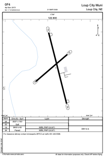


0F4 - Loup City Muni
Located in Loup City, United States
ICAO - 0F4, IATA -
Data provided by AirmateGeneral information
Coordinates: N41°17'11" W98°59'24"
Elevation is 2073 feet MSL.
Magnetic variation is 05° East View others Airports in Nebraska
Operational data
Special qualification required
Current time UTC:
Current local time:
Weather at : KODX - Evelyn Sharp Fld ( 38 km )
METAR: KODX 290853Z AUTO 26004KT 10SM CLR 04/03 A2983 RMK AO2 SLP111 T00390028 58003
Communications frequencies: [VIEW]
Runways:
| RWY identifier | QFU | Length (ft) | Width (ft) | Surface | LDA (ft) |
| 04 | 50° | 2021 | 100 | GRASS | |
| 22 | 230° | 2021 | 100 | GRASS | |
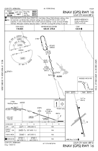
| 16 | 166° | 3900 | 60 | CONC | |
| 34 | 346° | 3900 | 60 | CONC |
Airport contact information
Address: Loup City United States