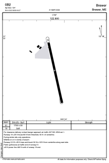


0B2 - Brewer
Located in Brewer, United States
ICAO - 0B2, IATA -
Data provided by AirmateGeneral information
Coordinates: N44°45'50" W68°46'4"
Elevation is 125 feet MSL.
Magnetic variation is -19° East View others Airports in Maine
Operational data
Special qualification required
Current time UTC:
Current local time:
Weather at : KBGR - Bangor Intl ( 7 km )
METAR: KBGR 160253Z 19003KT 10SM SCT120 BKN250 16/12 A2986 RMK AO2 SLP109 T01560117 50003
TAF: KBGR 152326Z 1600/1624 19007KT P6SM BKN150 FM160900 VRB02KT 4SM BCFG SCT004 FM161300 VRB04KT P6SM BKN080
Communications frequencies: [VIEW]
Runways:
| RWY identifier | QFU | Length (ft) | Width (ft) | Surface | LDA (ft) |
| 01 | 348° | 1730 | 30 | GRASS | |
| 19 | 168° | 1730 | 30 | GRASS |
Airport contact information
Address: Brewer United States