


03S - Sandy River
Located in Sandy, United States
ICAO - 03S, IATA -
Data provided by AirmateGeneral information
Coordinates: N45°24'6" W122°13'43"
Elevation is 704 feet MSL.
Magnetic variation is 19° East View others Airports in Oregon
Operational data
Special qualification required
Current time UTC:
Current local time:
Weather at : KTTD - Portland-Troutdale ( 21 km )
METAR: KTTD 032353Z 25006KT 10SM OVC075 17/09 A2981 RMK AO2 RAB2254E46 SLP093 P0000 60000 T01670094 10211 20161 58015
TAF: KTTD 032320Z 0400/0424 22007KT P6SM BKN100 FM040300 10005KT P6SM -RA OVC045 FM040500 11005KT P6SM -RA OVC030 FM040700 13005KT 5SM RA BR BKN008 OVC025 FM041200 24006KT 5SM -RA BR SCT010 OVC025
Communications frequencies: [VIEW]
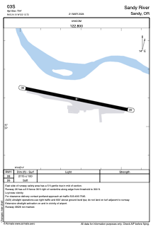
Runways:
| RWY identifier | QFU | Length (ft) | Width (ft) | Surface | LDA (ft) |
| 08 | 101° | 2115 | 100 | GRASS | |
| 26 | 281° | 2115 | 100 | GRASS |
Airport contact information
Address: Sandy United States