


02T - Wise River
Located in Wise River, United States
ICAO - 02T, IATA -
Data provided by AirmateGeneral information
Coordinates: N45°46'12" W112°58'50"
Elevation is 5830 feet MSL.
Magnetic variation is 17° East View others Airports in Montana
Operational data
Special qualification required
Current time UTC:
Current local time:
Weather at : KBTM - Bert Mooney ( 43 km )
METAR: KBTM 140653Z AUTO 00000KT 10SM FEW065 08/M03 A2998 RMK AO2 SLP110 T00781028 402280017
TAF: KBTM 140521Z 1406/1506 27005KT P6SM SCT120 FM141200 32008KT P6SM BKN100 FM141800 32012KT P6SM -RA BKN045 OVC100 PROB30 1419/1423 P6SM -TSRA OVC070CB FM150000 32010KT P6SM BKN100
Communications frequencies: [VIEW]
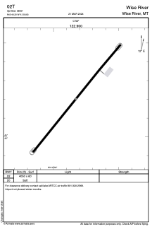
Runways:
| RWY identifier | QFU | Length (ft) | Width (ft) | Surface | LDA (ft) |
| 02 | 40° | 4050 | 60 | OTHER | |
| 20 | 220° | 4050 | 60 | OTHER |
Airport contact information
Address: Wise River United States