


Z47 - Engstrom Fld
Located in Basin Creek,
ICAO - Z47, IATA -
Data provided by AirmateGeneral information
Coordinates: N64°40'45" W165°17'57"
Elevation is 143 feet MSL.
Magnetic variation is 17° East View others Airports in Alaska
Operational data
Special qualification required
Current time UTC:
Current local time:
Weather at : PAOM - Nome ( 20 km )
METAR: PAOM 061753Z 19005KT 10SM SCT090 BKN120 06/02 A2975 RMK AO2 SLP074 T00610017 10067 20050 50004 $
TAF: PAOM 061739Z 0618/0718 VRB05KT 6SM BR SCT015 OVC030 FM062200 27007KT 5SM -SHRA BR OVC020 FM071200 VRB03KT 2SM BR VCSH SCT007 OVC015
Communications frequencies: [VIEW]
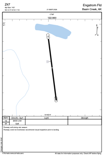
Runways:
| RWY identifier | QFU | Length (ft) | Width (ft) | Surface | LDA (ft) |
| 16 | 173° | 2000 | 60 | OTHER | |
| 34 | 353° | 2000 | 60 | OTHER |
Airport contact information
Address: Basin Creek