


YPAM - Palm Island
Located in Palm Island, Australia
ICAO - YPAM, IATA - PMK
Data provided by AirmateGeneral information
Coordinates: S18°45'19" E146°34'53"
Elevation is 30 feet MSL.
View others Airports in Queensland
Operational data
Special qualification required
Current time UTC:
Current local time:
Communications frequencies: [VIEW]
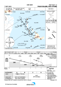
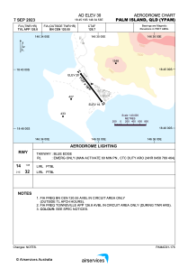
Runways:
| RWY identifier | QFU | Length (ft) | Width (ft) | Surface | LDA (ft) |
| 14 | 143° | 3724 | 59 | COP | |
| 32 | 323° | 3724 | 59 | COP |
Airport contact information
Address: Palm Island Australia