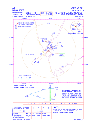
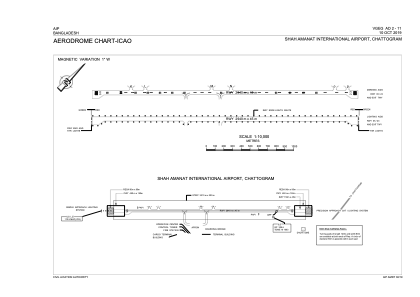


VGEG - Shah Amanat International Airport, Chattogram
Located in Chattogram, Bangladesh
ICAO - VGEG, IATA - CGP
Data provided by AirmateGeneral information
Coordinates: N22°15'25" E91°49'20"
Elevation is 14 feet MSL.
View others Airports in Chittagong Division
Operational data
Special qualification required
Current time UTC:
Current local time:
Weather
METAR: VGEG 061200Z 22007KT 6000 HZ FEW018 32/29 Q1003 NOSIG
TAF: TAF VGEG 061100Z 0612/0718 22008KT 5000 HZ FEW015 SCT100 BECMG 0615/0617 18006KT 4000 HZ SCT012 BKN080 TEMPO 0620/0704 14008G20KT 2000 TA/TSRA BKN010 FEW025CB OVC080 BECMG 0708/0710 18008KT 5000 HZ FEW0150 SCT100
Communications frequencies: [VIEW]
Runways:
| RWY identifier | QFU | Length (ft) | Width (ft) | Surface | LDA (ft) |
| 05 | 49° | 9646 | 148 | PEM | |
| 23 | 229° | 9646 | 148 | PEM |
Airport contact information
Address: Chattogram Bangladesh