


T54 - Lane Airpark
Located in Rosenberg, United States
ICAO - T54, IATA -
Data provided by AirmateGeneral information
Coordinates: N29°31'24" W95°46'47"
Elevation is 94 feet MSL.
Magnetic variation is 05° East View others Airports in Texas
Operational data
Special qualification required
Current time UTC:
Current local time:
Communications frequencies: [VIEW]
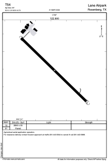
Runways:
| RWY identifier | QFU | Length (ft) | Width (ft) | Surface | LDA (ft) |
| 13 | 0° | 2890 | 35 | ASPH | |
| 31 | 0° | 2890 | 35 | ASPH |
Airport contact information
Address: Rosenberg United States