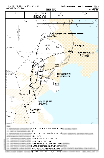


SSKT - Aeroclube De Santa Catarina
Located in Sao Jose, Brazil
ICAO - SSKT, IATA -
Data provided by AirmateGeneral information
Coordinates: S27°36'43" W48°40'24"
Elevation is 22 feet MSL.
Magnetic variation is -19.710694487° East View others Airports in Santa Catarina
Operational data
Special qualification required
Current time UTC:
Current local time:
Communications frequencies: [VIEW]
Runways:
| RWY identifier | QFU | Length (ft) | Width (ft) | Surface | LDA (ft) |
| 03 | 0° | 3947 | 59 | ASPH | |
| 21 | 0° | 3947 | 59 | ASPH |
Airport contact information
Address: Sao Jose Brazil
