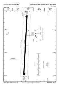


SBCZ - Cruzeiro Do Sul
Located in Cruzeiro Do Sul, Brazil
ICAO - SBCZ, IATA - CZS
Data provided by AirmateGeneral information
Coordinates: S7°35'58" W72°46'10"
Elevation is 636 feet MSL.
Magnetic variation is -7.119844441° East View others Airports in Acre
Operational data
Special qualification required
Current time UTC:
Current local time:
Communications frequencies: [VIEW]
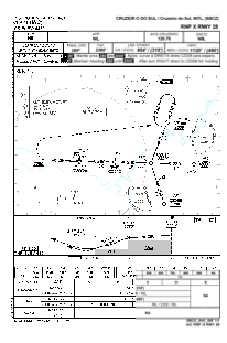
Runways:
| RWY identifier | QFU | Length (ft) | Width (ft) | Surface | LDA (ft) |
| 10 | 93° | 8268 | 919 | ASPH | |
| 28 | 273° | 8268 | 919 | ASPH |
Airport contact information
Address: Cruzeiro Do Sul Brazil