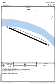


S68 - Orofino Muni
Located in Orofino, United States
ICAO - S68, IATA -
Data provided by AirmateGeneral information
Coordinates: N46°29'31" W116°16'31"
Elevation is 1005 feet MSL.
Magnetic variation is 18° East View others Airports in Idaho
Operational data
Special qualification required
Current time UTC:
Current local time:
Weather at : KLWS - Lewiston/Nez Perce County ( 58 km )
METAR: KLWS 230256Z 09006KT 10SM BKN055 OVC070 11/03 A2992 RMK AO2 SLP133 T01060033 53018
TAF: KLWS 222320Z 2300/2324 30004KT P6SM SCT060 BKN150 FM230500 22005KT P6SM BKN050 OVC100 PROB30 2307/2311 6SM -RA OVC040 FM231100 VRB03KT P6SM OVC028 FM231800 03005KT P6SM SCT035 SCT150
Communications frequencies: [VIEW]
Runways:
| RWY identifier | QFU | Length (ft) | Width (ft) | Surface | LDA (ft) |
| 08 | 0° | 2520 | 60 | ASPH | |
| 26 | 0° | 2520 | 60 | ASPH |
Airport contact information
Address: Orofino United States