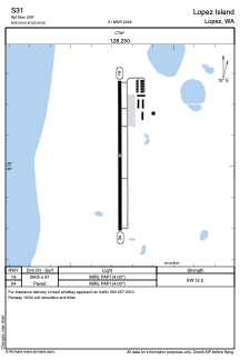


S31 - Lopez Island
Located in Lopez, United States
ICAO - S31, IATA - LPS
Data provided by AirmateGeneral information
Coordinates: N48°29'2" W122°56'16"
Elevation is 209 feet MSL.
Magnetic variation is 21° East View others Airports in Washington
Operational data
Special qualification required
Current time UTC:
Current local time:
Communications frequencies: [VIEW]
Runways:
| RWY identifier | QFU | Length (ft) | Width (ft) | Surface | LDA (ft) |
| 16 | 0° | 2905 | 61 | ASPH | |
| 34 | 0° | 2905 | 61 | ASPH |
Airport contact information
Address: Lopez United States